In October 2005, Memory Map launched v5 of their digital mapping product. At that time they moved away from naming their versions after the year they were released and it only took a couple of years to see why! Here we are, over 10 years on and they have just announced v6 of the same product (make sure you download v6.1 not v6.0.1)
You can see the initial release details here: Memory Map v6
To say that I’m underwhelmed by the feature list is an understatement, but, at the same time, I’m not surprised. The development of Memory Map, across all its platforms is glacially slow. I don’t know what their development team actually does, but this release is not significant enough to justify the full version number upgrade.
The two main, marquee features are Cloud Sync and AutoRouting. I have culled the following descriptions from the MM website:
Cloud Sync enables you to transfer routes, marks and tracks to and from your mobile devices via the internet ‘cloud’ rather than having to email or connect your device. Currently CloudSync is available on Android devices including the Memory-Map TX3 and TX4 Android GPS smartphones and will be added to the iPhone and iPad apps early in 2016.
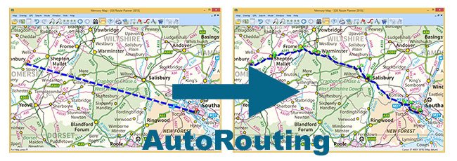
AutoRouting: Create a rough route, even just a straight line A to B, and then choose to Optimise Route for Driving, Cycling or Walking and Memory-Map will create a more detailed route for you automatically. The online database is great for car journeys and being improved all the time for walking and biking.
As far as Cloud Sync goes, it’s a great idea, but it’s not particularly well implemented. Why they didn’t just allow the use of DropBox or Google Drive I don’t know.
AutoRouting sounds awesome! Click two points on the map and then have MM draw the best route between them – how cool is that! But read the print carefully “The online database is great for car journeys and being improved all the time for walking and biking” – doesn’t sound very promising for walkers really. However, I’ve done a couple of quick tests and it doesn’t work too badly. It even works in Scotland, where there are no defined Rights of Way on the OS maps. The resolution of the produced route isn’t great, more waypoints would be good, and a couple of tests produced ridiculous detours, where a short, Open Access route would have worked better. I will watch this feature with interest.
A couple of minor items on the feature list are interesting, for various reasons;
Coloured Waypoints: you can now colour your waypoint icons, well most of them anyway. Again it sounds good, but the implementation is pretty awful. Icons don’t seem to have their own colour anymore, they appear to take on the colour of the icon you have set to be the default icon.
Default GPX: The default import and export file extension is now GPX, rather than their own MMO format. I can’t fathom this change at all. The MMO file format is much more functional in the desktop version of the software than GPX is. By all means allow us to select the default extension, but don’t force us to use GPX!
Also, any MMO files you create with v6 will not then open in v5 – even if they have been created in v5, opened in v6, not changed, then saved with v6. A strong sense of Deja Vu hit me (I spent a lot of time moving from v2004 to v5)! Surely it’s possible to create a ‘Save As v5’ option when we export?
Undo: There are now multiple layers of Undo, and it seems to be a bit quicker than previously.
Windows Mobile Device: Gone! If you still use a Windows Mobile PDA (like I used to) then don’t upgrade to v6, they are no longer supported. To be fair, this isn’t going to impact many people. You should be using Android mobile devices now and the very, very useful MM Tracker!
Supports existing map purchases: probably the best of all the features, is what anyone who has only been using MM for a couple of years would have expected, but is actually a complete change to previous releases. You can use your v5 maps with MM v6! You don’t have to buy them all again, like I did when I upgraded from v2004 to v5! Apparently this is due to a change in the OS licensing rules – and not before time.
What’s still missing?
Most of the things I was hoping to see in a ‘major’ new release of Memory Map are still not here.
- The ability to split or join a Route – probably the major bug-bear I have with MM
- The ability to drag an area around a group of waypoints (or Marks) and delete them – deleting large numbers of waypoints can be painful
- A faithful conversion from a Track to a Route – without losing the path detail of the track
- Some sharing capability with social media platforms (Twitter for me, but I’m sure others would like Facebook, G+, etc.)
- Direct Import and Export to Google Earth formats, KML and KMZ
- Improved performance when handling large Overlay – in fact things seem to have gone backwards in this area (see below).
Performance test
I carried out a simple side-by-side performance test for MM v6.0.1 and MM v5.4 just to see how much performance had been improved in the new version (you would expect better performance wouldn’t you?)
I loaded a number of routes into both versions of MM and then zoomed in from the furthest out view to the closest view in the same 1:25k scale map. There are about 30 routes in the test file, each with a couple of hundred waypoints. The results can be seen in the two videos below. Watch them in order, and see the visible difference in just this simple test.
MM v5 Performance Test
MM v6 Performance Test
The performance of v6 is appalling! It does double redraws of the map at almost every zoom level and takes much longer to render the waypoints at each zoom level. The same zoom in and back out again operation takes almost twice as long in v6 as it does in v5 – I’m not sure how this is an improvement at all. The tests above were done on an Intel Core i5-4200U CPU running 64bit Windows 10 with 8Gb RAM – not exactly a powerhouse PC, but not a slouch either!
Despite my lack of enthusiasm for the new release, it does at least still allow you to use your existing maps, so I’ll be doing some more testing to see how good (or bad) it is. I also decided to update my existing parallel User Guide at the same time.
I will release those over the coming days (possibly weeks), brought right up to date with all the new stuff in v6 (could you tell my tongue was firmly wedged in my cheek there)?


